 Contact us
- LDM cooperative automated Driving system combines and processes road information and transmits it to vehicles as V2X messages without driver involvement.
- LDM cooperative automated Driving system combines the dynamic information of C-ITS and the static information of HD map into LDM standard and generates accurate location information for transmission.
SERVICES
- Local Dynamic Map
Local Dynamic Map
This precision map-based system collects, processes, transmits, stores, and maintains real-time dynamic information
(sensor data, weather, roadside unit data). Essential technology for cooperative automated driving
level 4 or higher, the system analyzes vehicle, pedestrian, and structure data for safe driving.
(sensor data, weather, roadside unit data). Essential technology for cooperative automated driving
level 4 or higher, the system analyzes vehicle, pedestrian, and structure data for safe driving.

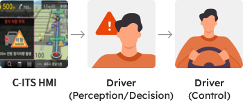
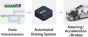
C-ITS and LDM Cooperative automated Driving System Comparison
 Move the screen left or right
| Category | C-ITS Road Infrastructure System | LDM Cooperative Automated Driving Road Infrastructure System |
|---|---|---|
| Purpose | Provides information (text/image) to drivers | Provides quantified data to self-driving controller |
| Dynamic Information Collection Method | Infrastructure sensor, traffic information center, vehicles | |
| Service Provision Method | SAE J2735 Message set | |
| Location Information Generation Method | Static information set during development | Real-time generation using HD map, improved accuracy |
| Capabilities | Simple transmission of collected data | Delivers a combination of collected information and map data |
| Response to Road Changes | Requires software repair and maintenance | Able to respond with updated/distributed HD maps |
| Service Flow |
|
|
- WAYS1 Inc.CEO : Hwang Seung HoBusiness Number : 409-86-53561
- Head office : (16006) D-521, Indukwon IT Vally, 40 Imi-ro, Uiwang-si, Gyeonggi-do, Republic of Korea
- R&D Center : (13493) A-313, 240, Pangyoyeok-ro, Bundang-gu, Seongnam-si, Gyeonggi-do, Republic of Korea
- Tel. : +82-31-8069-7887Fax : +82-31-8069-7899E-mail : contact@ways1.com
Copyright© Ways1 Inc. All Right Reserved. Site By THREEWAY